Showing posts with label walks. Show all posts

Sunday, 23 December 2007

The White Route: Sherds, Sherds and More Sherds OR Alonissos Travelogue Part 11

Over the years, I have steadily added my own touch to the standard Greek holiday activities of swimming, trekking and eating. First there was fishing, a fleeting fad brought to an abrupt end when Maria arrived on the scene with her swift judgement that no man of hers should come within down-wind smelling distance of fish, nevermind 'murder' them. Next, there was an equally fleeting love affair with geology which for the most part saw me needlessly burdening myself with interesting looking rocks in the course of a holiday's walking only to chuck them all away at Eleftheros Venizelos airport flummuxing thus the odd itinerant geologist. And of course there has always been a healthy interest in cafes, with many an evening spent combing cycladic alleyways in search of the perfect view to accompany a sundowner... or two.

But none of these myriad ways to eat up time when not actually trekking or swimming can come close to the thrill of amateur archaeology. I always had at least passing interest in exploring the rich variety of ancient sites to be found on the islands, but it was not until I met Maria that my wall climbing and earth raking took on a more serious air. With 13 years spent studying the ancient artefacts of the Aegean, as well as practical experience of excavations, she was well placed to point me in the right direction.

Not that there was any great secret about it: all she did was make a casual remark while climbing up a low hill on the site of a Mycenaen Acropolis near Naoussa, Paros in the Autumn of 2004

"This place is full of pottery", she remarked.
"Really!? Where!?", I responded whirling round and raking the panorama less it should fly off like some startled bird
"Under your feet silly", she added tramping on ahead.

I looked down. She was right; the entire site was strewn with fragments of rust coloured sherds. What seems so painfully normal and obvious 3 years later - that even the most scrupulously excavated ancient site will contain traces of pottery - seemed like a revelation back then. I bent down to take a closer look, picking up an interesting sherd and rolling it around in my hands, only to toss it aside when a brighter or bigger one caught my eye.

Simply put, this discovery was a revelation, and even more so when I found fragments of fine-wear vessels whose light black brush strokes made even Maria excited.

Since then, I have always kept a keen eye out for finds, especially while exploring the more remoter sites, and thus have unearthed such finds as fragments of bronze, cup marks and even obsidian flakes in addition to scores of interestingly painted sherds.

But I had never seen anything like the amount of sherds scattered around the unexcavated site of the classical era pottery factory at Tsoukalia. Not only was the beach thick with ostrika, many of the chunks were sufficiently large enough to incorporate whole handles and lips. Here are just a few of chunks that I found lying around.
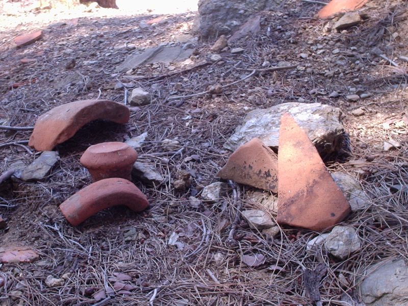

However, despite this wealth of finds, I found the location of Tsoukalia to be a little disappointing. Although initially impressive, on closer inspection the vast array of pottery appeared to be composed almost entirely of coarse wear, with few indications as to which period, ancient or not, they might date from. Also, the beach too was a little uninviting as the prevailing northerly winds had raised the waves and chased a fair amount of rubbish into the bay.

So it was that having clambered about in the sherds for while, exchanging first one then another for a brighter, bigger chunk, I decided to hit the road again, this time bound for the picturesque chapel of Agoi Anargiroi.

Tuesday, 11 December 2007

The White Route: A to E via Q, Z, and X... OR Alonissos Travelogue part 10

Looking back on my ten days of walking on Alonissos, I am on the whole proud of my little adventures: not only did I cover a hell of a lot of terrain, I did so with the minimum amount of getting lost. Equipped with an accurate map, two independent descriptions of each route and most of all, the patience to study the lay of the land and the position of the sun with some degree of accuracy, I almost always made my way from A to E via the logical progression B then C then D.

The spectacular exception to my otherwise impeccable sense of direction came during the next stage of the white route from Mega Nero to Tsoukalia. On paper this stretch appears impossible to cock-up, not least of all because a sign-posted asphalt road separates the two locations by all of a 30 minute walk. However, on leaving Mega Nero, little did I know that I was about to embark upon an unplanned excursion up a mountain.

In my defence, I was subject to mitigating circumstances: I had set out on this route backwards.

Flashback to the early morning of that day. Andrew sits outside his tent, drinking coffee and studying the map...

... So where do I want to go today?.. Tsoukalia, yes... Oh and here's the walk to Tsoukalia in the guide book, excellent... but wait a minute... this route goes first north to Megali Ammos before taking in Tsoukalia on the way back... I'd much prefer to go the opposite way... I wonder if it is possible to follow the directions from the end of the walk and work back to the beginning and still be able to follow the route?... let's try... [...] ... seems easy enough, all I have to remember is that left is right and right is left... got it. Piece of cake!

And it was... right up until the point when I was directed to walk up a gorge.

I think you may be one step ahead of me here... but let me pull you back a little to walk a ways with me in ignorance so that I can tell you how it all happened.

Like I said, an asphalt road links Mego Nero and Tsoukalia, but the route described in the guide neatly avoids this completely by following a dirt track beginning some metres before the turn off to Tsoukalia, and leading one on a path through a charmingly sheltered patch of pine forest. In fact, this path penetrates so deeply into this patch of woodland that after fifteen minutes or so, the road disappears from sight altogether. It was at this point that I understood that I had to turn right; that is, had I been doing the route in the direction that the authors intended, I would have been directed to turn left at this same point having just emerged from the direction in which I was now about to set out...

...Got it? Not so easy after all, eh?

Anyways, what threw me here was not the cat's cradle of figuring out left from right, this was relatively simple; rather it was the more prosaic yet infinitely more frustrating situation of being confronted with 2 possible rights. Indeed a path did slope down away from me to the right, but on closer inspection, this forked after 10 meters or so leaving me with no indication just which of these two rights I should take.

The intrepid walker will often be faced with this very dilemma, though it should be the aim of all guide books to eliminate the agony of such 'russian roulette' moments. In practice one must call upon all one's resources to make an informed choice: the lay of the land, the position of the sun, moss growing of the northern side of tree-trunks (and other such 'boys' own' fun). However, in those cirumstances where doubt persists, there is no other solution than to choose a path, set out, and seek to confirm or reject your groundless hypothesis by checking the lay of the land against the description of the route.

Choosing the left fork, I wandered down a wide path flanked on one side by pines and on another by an olive grove before arriving at a little track which left the wider path to the left and led me into a shallow gorge. As all this checked out against the description of the route, adjusted, naturally, to compensate for my backwards direction, I felt confident that I was now within a brief walk a Tsoukalia.

Safe in the knowledge that I was well and truly on track, I paused for while in the little gorge to enjoy the silence. Just where I had entered, a handful of olive trees stood in a flat patch of long grass, sheltered from the elements and presumably well watered by what would have been a seasonal stream. Although I must have been a short walk from the road leading down to Tsoukalia, I might as well have been in the middle of nowhere; so quiet it was. Paradoxically perhaps, the sense of peace was made more intense by two hawks which at that moment were circling above me, plaintively screeching and every so often swooping close enough for me to hear their wings cutting through the air.

Perhaps it was the fact that I was caught up in the atmosphere of this little place; perhaps it was the sense that the difficult part was behind me. Whatever it was, when I got up and looked at the map to figure out in which direction I should walk to get to Tsoukalia beach, I did not walk down the gorge as common sense would dictate, but up it. What had momentarily escaped my attention was that when you read route directions backwards, not only should left be read as right, but following a similar topsy-turvy logic, up the gorge should actually be rendered as down it.

Think about it...

So with a spring in my step, a song in my heart and two harbingers of doom screeching and swooping above my head, I set out to ascend the gorge.

Two minutes later I hit a dead end: a dense thicket of thorns blocked the conventional ascent up the bed of the gorge. No worry, I thought as I took to a narrow and precipitous goat track ascending sharply up the right face of the gorge. Within a further twenty metres or so, this petered out, as so often is the case with goat tracks, leaving me to rely solely upon my sense of direction to see me through to Tsoukalia (which, as you will no doubt realise, was situated at an ever increasing distance behind me.)

Things went from bad to worse. The terrain became first steep and rocky, forcing me up ever higher onto the mountain and away from the gorge, then, when I had hit a sufficiently high enough altitude as to impress upon me most forcefully that I was definitely not headed for the coast, I found myself in the midst of a dense thicket of hollyoaks. The sun was pretty high at this point, and I was running desperately low on water too. And to top it all, the hawks were still relentlessly pursuing their quarry high above me. But despite all these set-backs, I remained cheerful: there are precious few opportunities to feel like a hero in this day in age... especially if you are the English teacher in a small provincial German town.

Eventually I broke out of the cover of the hollyoaks to see a little church crowning the ridge at the head of the gorge, which I could now see as a dark gash into the landscape way below me. Checking this against the map, I realised it must be the panagia sto boyno and knowing it to be loacated in the direction of a natural spring, struck out for the little church. After a few moments I came to some residential houses and a dirt road, and with half an hour I was drinking cool clear water in the shade of the little church.

Having quenched my thirst, I took stock of my situation. I still couldn't figure out what had gone wrong down in the gorge, but that mattered less than trying to salvage the walk. A glimpse at the guide revealed the answer: if I were to retrace my steps back along the dirt road, away from the church in the direction of the houses that I had seen, would come to the end of the road and a large property surrounded by olive groves. Arriving at the gate of the yard of this property, I should follow the perimeter wall in search of the familiar red splodges of paint upon boulders that seem to act as way markers throughout the Aegean.

Sure enough, as soon as I left the gate of the house and entered the olive grove, I found a string of way markers which eventually started to lead me back down the mountain. After a short while I entered pine forest again and the path began to get steeper and steeper... and every so often as I glimpsed the sky between the pines I could see the pair of hawks circling, swooping and screeching.

It was a beautiful walk, as usual accompanied by a symphony of sights, sounds, and smells: again the air moving through the trees, again the heady resinous scent of the pines; but this time the kind light of the forest floor and everything punctuated by the mournful screeching of the hawks, whom I was now considering less as harbingers of doom and more as companions on this little adventure.

After a while, I reached the edge of the forest and as is so often the case in dear green Alonissos, the beginning of an olive grove. Here, the ground became ridiculously steep, necessitating my gingerly proceeding crab like, inch by inch down a rugged track. But this was to be the last obstacle. Soon the landscape gave way to gentle tiers of olive groves affording a view of the last leg of the asphalt road down to Tsoukalia.

On hitting the road I heard the sea, which soon revealed itself... as did several hundred thousand pottery sherds.
.

Monday, 19 November 2007

The white route: spiders, cypresses, startled fowl and springs OR... Alonissos Travelogue Part 9


Having picked Dave and Gerry's brains about where to go the previous night, I thought it might be nice to walk to the beach of Tsoukalia on the South West coast to take in the as yet unexcavated classical era pottery factory located there, before looping up a little further on the west coast to visit the picturesque church of Agoi Anargiroi and the nearby coves of Tourkoneri and Megali Ammos.

It would be a long walk, all of eight hours what with breaks and swimming time, so I set off nice and early bound for the starting point of Patitiri... and the harbour shop to get myself my breakfast of a little tub of 'Total' yoghurt with a couple of miniature preserves of honey. This I slowly savoured under a tree down by the harbour, enjoying the comings and goings of a work-a-day port.

As with the red route, this white route starts with a thoroughly pleasant stretch once you clear the perimeter of Patitiri. The path proper begins at the first hairpin bend on the road up to the Hora where a sign for Mega Nero, ostensibly pointing at the house situated on the bend, but actually sending one up a slope skirting the perimeter wall of the house, leads, after a couple of minutes, into the familiar Alonissos landscape of pine forests and olive groves.

It was amazed to find this Arcadian stretch with its herb strewn paths and surprisingly dense thickets of ferns so near to the main road up to the Hora. It seemed like I had been transported into a different land on clambering up that little slope -- an impression made all the more forceful by the fact that one emerges into the little glade from the relative darkness of a thick kopse of pines.


I was used to seeing such undergrowth in the forests and moorlands of Scotland, but not in the Aegean in late July!

I should also add that other attractions on this five minute stretch included...

A: Startling some kind of wild fowl on rounding a bend (being Scottish I would identify it as a grouse or partridge or something like that, but I feel sure this can't be right). It had been hidden from view in the kind of thick undergrowth you can see above when this lumbering giant happened along, causing it to take to the sky with much clucking, flapping and fuss (beware of spoonerisms here).

B: Taking a momentary wrong turn on my way back through this glade and briefly entering the narrow channel of a track that, by the looks of things, hadn't been used in a while. I was quite sure of this as no sooner had I entered the space between the two hedgerows than I found myself gazing eye to eye with a huge spider (and I mean big enough to make the author yelp expletives of terror and surprise) perched horny and crab-like in a thick spun web which totally sealed the entrance to the path.

C: Cypress trees. Three of them. Baby ones. I do like cypress trees.

After this idyllic little stretch, I emerged at the spring of Mega Nero. Here, in a little depression surrounded by fields, was a rough build concrete trough in which a couple of taps had been inserted. As I ventured closer to fill up my bottle with the cool water, bravely sweeping aside the clouds of thirsty wasps grazing from the droplets clinging to the underside of the taps, I once more wondered just how it was possible to have the miracle of fresh running water in this parched land. As I had learnt the previous night from Dave and Gerry, those islanders who weren't fortunate enough to be connected to the mains water supply had to make do with collecting and storing what rain water they could by their own means and filling up the rest of the time from springs such as this one. It was another hot day, the earth was cracked from weeks, if not months of drought; yet here was an abundant reserve of water which was not only openly available to all, but which at that moment was leaking its way back into the earth by virtue of numerous instances of careless plumbing.

My water bottles replenished, my hair soaked with cool water, I was ready for the off once more. So, greeting the old woman gathering the lush sprigs of horta thriving in the midst of this little oasis, I hit the road.

I guess I should start publishing these walks in installments as they are growing way beyond control and heaven forbid that I should bore the few people who aren't even reading anyway.

Off the beaten track and back for a beer OR... Alonissos Travelogue Part 8

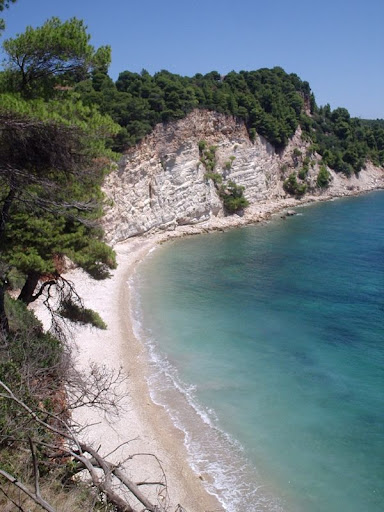
The day after the red route, I walked up the eastern side of Alonissos as far as Chrysi Milia. It was a nice walk at stretches, especially the cliff top path north from Spartines beach where I snapped the following photo:

View of second, more northerly Spartines beach from the cliff top path between the two beaches

But besides this stretch, however, it really was a bit of a disappointment. It was the one time that I abandoned the guides and set off in search of that most satisfying route: the coastal walk. One of the first places in Greece that I ever went walking was on the south west coast of Crete. Here, in the region of Hania, where the White Mountains tumble into the Libyan Sea, are miles of coastal paths stretching almost the whole length of the region. With the proximity of the sea on one hand and the mountains on the other, such walks are always a real joy.

Unfortunately, the topography of the south-eastern coast of Alonissos is such that no route can feasibly be undertaken over the jagged outcrops, scree-strewn ravines and, at times, residential housing that characterise this coast. Time and time again I was forced to make headway on the asphalt, thus losing instantly that childish yet highly agreeable sense of being an explorer.

Anyway, when I got to Chrysi Milia after a 3 kilometer stretch on the asphalt to find the tiny beach packed with young families enjoying the only sandy beach with shallow water on the island, their young kids volubly voicing their wants, I decided that I had had enough. After a fruitless period awaiting service at the crowded
taverna, I phoned a taxi and escaped back to Patitiri where I beered and tramped cheerily back up to the campsite on my little path through the pine forest.

That night, I finally met up with Dave and Gerry and enjoyed a sociable evening up in the old town over a few beers and a plate of yemista. It was a chance for me to effervesce about many of things that I here describe as well as get a few tips about where to go next.

And so it was that awaking the next day, just a little fuzzy headed, with another day's walking ahead of me, I knew just where I would go.

Sunday, 11 November 2007

The Pre-amble to the Ambling... or Alonissos Travelogue Part 6


The aim of the posts that follow is not to provide a detailed description of the walks of Alonissos. As I mentioned in my previous post, such guides can be found in the form of Keller and Tsoukanas' "Walking on Alonissos" as well as the internet site:

http://www.foxysislandwalks.com/AlonissosMain.htm

My aim, rather, is to give you a sense of what it is actually like to walk the paths of Alonissos with reference to some of the highlights of my tour. In addition, I will also try to ensure that future walkers are well enough informed to avoid the very few tricky situations in which I found myself after following, as best I could, complicated, vague, or just plain baffling descriptions of the route.

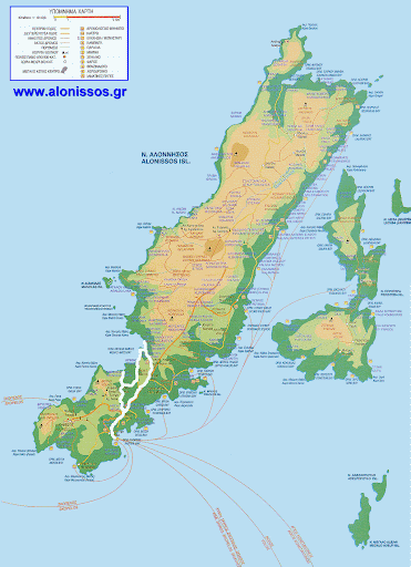
For the purposes of writing up my experiences to entertain rather than inform, I have divided my ten days walking into 4 routes . These I have illustrated with regard to the following map and the accompanying descriptions below.


KEY

RED: Plaka Campsite - Vythisma - Megalos Mourtias - Hora - Gialia - Kalderimi into Patitiri - Plaka

WHITE: Plaka Campsite - Mega Nero - Tsoukalia (via forest / gorge walk) - Agoi Anargiri - Tourkoneri - Megali Ammos - Mega Nero (via Raches)

PINK: Plaka Campsite - Mega Nero - Raches - Isomata - Agios Petros - Steni Vala - Ghlifa - Steni Vala (bus back to Patitiri)

YELLOW: Mourtitsa - Strovili - Kastanorema Gorge - Mourtitsa

As you can see, with the exception of the Kastanorema Gorge walk, the bulk of the walking to be done on Alonissos centres around the south and central parts of the island. This is not to say that walking opportunities do not exist in the north of the island; but these present themselves as a less attractive option than the circular routes of the south and centre which can be more satisfyingly negotiated from a base in one the charming settlements to the south of the island. More importantly perhaps, the southerly walks in particular afford the opportunity to break one's journey in a cafe to sip a frappe, take in the views and rest on one's laurels for a while.

It should be noted, however, that my actual movements during the time that I spent on Alonissos bare little resemblance at times to these four routes - both insofar as they appear on the map and as they are related below - and that what you will read here is, in keeping with the rest of this travelogue, 'a story'. Although I have made every effort to be scrupulous where accuracy has mattered, I have, in most other cases, been guided by the requirements of style.

And so to the walks...